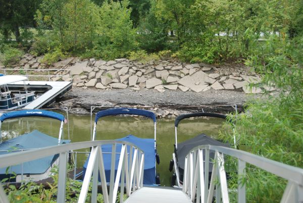
February marks the low water period at many flood control reservoirs across North America. In most instances, levels have been drawn down to allow room for the waters the annual spring runoff will bring; other lakes’ levels are dropped to allow waterfront residents and marinas to repair docks. Whatever the reason for the lowest water levels of the season, now’s a great time to grab a handheld GPS, cell phone, hand-bearing compass, pen and paper—or all of the above—and take a hike around your local lake.
Get Off The Shore
When I say “around,” I don’t mean staying on the bank; I mean walking around in the basin that will be flooded in a few months from now, but for the time being, is high and dry and revealing itself like no other time of year.
 Bottom features that attract fish and the bait they follow when submerged and hidden by water become readily apparent when literally underfoot, and are worth noting. A rock pile in the midst of a broad plain of sand and gravel will be a magnet to fish in a few months. Stumps and posts from an old fencerow, flooded when the reservoir was filled and now temporarily exposed, will hold fish that stick to the linear feature, even following it from deep water to shallow and back through the season once it’s back under water. Roadbeds and bridges that are underwater all season serve as current breakers and gathering places for baitfish and gamefish alike, locations that require time and effort to locate with sonar when under 20 feet of water in May, but may stick out like the nose on your face on the drained landscape today.
Follow The Flow
Original creek beds and the paths they still trace even while covered with several fathoms of water in the spring offer deep water paths for fish to follow. When the waters are dead-low sometimes the only water found in a reservoir remains in those waterways, so they are worth remembering.
Stump fields, flooded woodlots and even old foundations are all features that fish are drawn to under water. At my local water supply reservoir, the source of a consistent bite that took place every spring over a series of small humps atop a long, shallow flat revealed itself one winter when waters receded to reveal several cement burial vaults that had been overlooked when the country church at the site was demolished and flooded along with its adjacent cemetery. Over the years, waves, boat wakes and current action washed away the earth, covering the burial sites, revealing the structure that had concentrated fish for decades. Those who recall the debacle don’t fish there anymore, and it’s not just because the habitat features were removed and relocated.
Even in lakes where drawdown is not dramatic, the lower water levels that come naturally this time of year often reveal shoreline cover and structure that is hidden from view the balance of the season—when it is harboring fish seeking shelter or places to feed.
 Taking Notes
The key to taking advantage of the windfall of information about deadfalls, sunken rock piles and other sub-surface structures that reveal themselves this time of year is documenting the locations of same in a manner that will allow you to return to the exact same spots when they are covered in water.
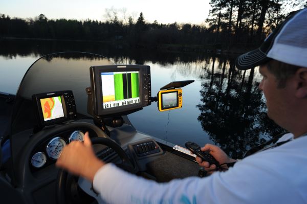
The easiest way to do so is to use a handheld GPS and stand amid the structure while saving the coordinates or marking it as a waypoint. Some GPS models offer a camera feature which is handy to take and keep photos of the structure you are marking to jog your memory of just what’s down there once it’s covered with water. Transfer the coordinates to your boat’s GPS or just bring the handheld unit with you next season and let it direct you to the now-flooded location.
You can also use a hand-bearing compass to get magnetic bearings of objects on shore while standing at the spot you want to mark and return to. By noting the resulting position lines and where they intersect, you can use your boat’s compass to return to the exact spot next season.
Or within casting distance of same; nothing scares fish off structure like the jarring arrival of a Danforth in their midst!